
Map Academy: get mapping quickly, with QGIS
Go from map zero to map hero with QGIS: 'heat maps', locator maps, election maps, density maps, analysis, design + more
Lo que serás capaz de hacer
WELCOME TO MAP ACADEMY! LEARN HOW TO MAKE GREAT MAPS, WITH QGIS Update: I now have over 16,000 people learning with me, in 180 different countries - thanks so much! I also try to reply to all comments and reviews so you should always be able to get in touch with me. Millions of people across the world love maps, yet only a small percentage of people know how to make maps - and I'm on a mission to change that. Taking your first steps in geographic information systems (GIS) and digital cartography can be really enjoyable, but if you don't have a guide it can also be a wee bit daunting, so that's why I've launched Map Academy. Using real data from many different countries, this course contains over 140 short lessons to help you get up and running with map making and spatial analysis in QGIS. If you want me to add a new video on a topic of your choice, just get in touch and I'll do my best to create one! QGIS is the world's most popular open source GIS and is used by major corporations worldwide, as well as by national, regional and local governments - and by academics, students and amateur map enthusiasts. It's 100% free, and it works on Mac, PC and Linux. QGIS downloads and installs in minutes and requires no licences or registration - ever. By the end of this course, you'll be able to make many different kinds of maps and save them as high quality images in a variety of file formats (e.g. pdf, jpg, png, and many more) for use in documents, presentations and other settings. You might be surprised at how much you can learn and how far you can go with QGIS in a short space of time. Map Academy: Get mapping quickly, with QGIS is organised into the following sections: Introduction Know your way around QGIS Let's make a map Data handling Locator maps 'Heat maps' Election maps Density maps Fun map stuff Vector tools in QGIS Working with raster data QGIS Plugins Tips and tricks Recap Okay, so why QGIS? Yes, it's 100% free, but that's not why I want you to use it. The main reasons we use QGIS in this course are as follows. BEAUTY : you can produce beautiful maps in QGIS, with minimal fuss. SPEED : it's fast - it helps you get the job done quickly and meet those pesky deadlines. POWER : its powerful - you can do all kinds of complex spatial analysis with it and go way beyond mapping, if you need to. INNOVATION : the QGIS development team are always making improvements and adding enhanced features. FLEXIBILITY : QGIS can handle any file type, and works on any operating system. But what if you only need to make simple maps? No problem - it's great for that too. You can use QGIS to make basic maps, as well as performing more complex mapping and spatial analysis tasks - if you need it, QGIS can do it. Like all software, the initial learning curve can be a bit steep and you can quickly become overwhelmed with words, concepts, data formats and menu options - not to mention the unsettling feeling you can get when you first look at a new user interface. You can find lots of QGIS tricks and tips online, but if you're just starting out with GIS it's often difficult to know what terms to search for, where to look, and who to trust. This is why I've launched Map Academy here on Udemy. This QGIS course is a systematic, step-by-step introduction that begins with the basics of GIS and data, and guides you all the way through different map types and how to create high quality outputs. Along the way, you'll learn a ton about fundamental GIS concepts and techniques, all based on the idea of doing-as-you-learn and learning-as-you-do . I'll provide a wide range of interesting, in-depth examples from across the world so that you can apply the learning here to your own specific needs. I'll provide all the data you need - as well as showing you where to find more when you need to ( a crucial skill for any GIS user ). I assume no prior knowledge or experience of QGIS, or any other GIS software. So long as you're comfortable using a computer, are enthusiastic about maps, and love learning new things then this course is for you. I look forward to seeing you in class! - Alasdair :)
- How to make different map types (e.g. 'heat maps', locator maps, density maps, election maps - and more)
- Map making workflows - adding data, styling data, labelling, design, map layouts and more (including glowing maps)
- The fundamentals of QGIS (100% free software, no license or payment required)
- How to export high resolution images from QGIS (e.g. png, pdf, jpg, svg and more)
- Spatial analysis concepts (buffer, clip, etc)
- The fundamental principles of GIS
Temario
UNIDAD 1 - Introduction · 9 leccionesUNIDAD 1 - Introduction
UNIDAD 1 - Introduction
- Course overview: start here
- A few words about Udemy reviews
- A brief intro to GIS and QGIS
- Terminology: vector, raster and more
- A message about unzipping files (for anyone who needs it)
- Installation of QGIS (via qgis.org)
- Possible MacOS install issue - easy fix
- Time to open QGIS now!
- Can you answer these questions?
UNIDAD 2 - Know your way around QGIS · 13 leccionesUNIDAD 2 - Know your way around QGIS
UNIDAD 2 - Know your way around QGIS
- Know your way around QGIS - introduction
- A quick tour of QGIS
- Map colours and map navigation
- How to change map projections
- Saving QGIS projects
- QGIS on different operating systems
- Change the way QGIS looks
- Don't forget the Help menu in QGIS
- The QGIS status bar
- The View options in QGIS
- How to identify features in QGIS
- A little reminder of the QGIS interface
- A QGIS 'what's what' quiz
UNIDAD 3 - Let's make a map · 11 leccionesUNIDAD 3 - Let's make a map
UNIDAD 3 - Let's make a map
- Let's make a map - introduction
- Get the data and add it to QGIS
- Change the colour of layers in QGIS
- Take a look at the attribute table
- Create a basic world map
- Finalise and export our world map
- Make a country map with QGIS
- How to use the layer styling panel
- Use duplicate layers in QGIS
- Change the layer style in QGIS
- Make a map of your country, showing your home town (or nearest city)
UNIDAD 4 - Data handling in QGIS · 17 leccionesUNIDAD 4 - Data handling in QGIS
UNIDAD 4 - Data handling in QGIS
- Data handling - introduction
- BAD DATA!
- Add a vector layer to QGIS
- Tips for when you add data to QGIS
- Add a raster layer to QGIS
- Map a csv file with latitude and longitude in it
- Add data via the QGIS browser
- So, um, what is a shapefile?
- ? A little bit about map projections ?
- Getting used to attribute tables in QGIS
- Convert file formats in QGIS - easy!
- Quickly add a base map to QGIS (OpenStreetMap)
- The political nature of map data
- Filtering a layer in QGIS
- Join a spreadsheet to a map layer
- Help! Where can I find GIS data for my area?
- Find all the errors/things in the us-states-bad layer from the BAD DATA lecture
UNIDAD 5 - Locator maps · 14 leccionesUNIDAD 5 - Locator maps
UNIDAD 5 - Locator maps
- Locator maps - introduction
- Let's look at a locator map (just watch this one, we'll add data in next video)
- Get the data, add it to QGIS
- Let's filter our map layers
- Let's style our locator map
- Labelling layers in QGIS
- Add title text to your map in QGIS
- Export your map from QGIS (png, jpg, pdf, any format!)
- A brief tour of the Print Layout - before the next video
- Print Layout locator map 1 (using 'lock layers')
- Print Layout locator map 2 (using a map theme)
- Edit your locator location!
- Where's Buckingham Palace? A longer locator example
- A little locator map quiz
UNIDAD 6 - 'Heat maps' (actually called choropleth maps :)) · 14 leccionesUNIDAD 6 - 'Heat maps' (actually called choropleth maps :))
UNIDAD 6 - 'Heat maps' (actually called choropleth maps :))
- Heat maps (mapping data values) - introduction
- Let's grab the data!
- Add the data to QGIS now
- Join data to your GIS layer
- Apply a colour scheme to our map (let's create a choropleth map!)
- Manually adjust data classes in your map
- Let's add our map to a Print Layout
- Add text to the Print Layout
- How to add a map legend in QGIS
- Exporting a Print Layout in QGIS
- Some Print Layout design ideas
- Some bonus font and text tips
- A little 'heat map' quiz
- Send me a map!
UNIDAD 7 - Election maps · 12 leccionesUNIDAD 7 - Election maps
UNIDAD 7 - Election maps
- Election maps (mapping categories) - introduction
- A 2019 UK election geopackage
- Let's style the UK 2019 election map
- Make an election map in the Print Layout
- How to add a small inset map
- Small multiple election maps
- Let's look at the 2020 US election
- US 2020 election map styles
- A US 2020 Print Layout
- A proportional symbol election map
- But which election map is right?!?
- A little election map quiz
UNIDAD 8 - Density maps · 10 leccionesUNIDAD 8 - Density maps
UNIDAD 8 - Density maps
- Density maps - introduction
- London density data - yum yum!
- Using the 'Heatmap' style in QGIS
- Count points in polygons
- Density - but by what measure? (e.g. per 10,000 people)
- Tips for filtering messy data
- Let's look at grid square density
- A simplified density map layout (a longer example)
- London hotel density Print Layout
- A little density map quiz
UNIDAD 9 - Fun map stuff · 13 leccionesUNIDAD 9 - Fun map stuff
UNIDAD 9 - Fun map stuff
- Fun map stuff - introduction
- Types of polygon fill in QGIS
- How to use a custom point marker
- Flows and glows (global flights!)
- Blend modes in QGIS (a little NZ example)
- Weird bounding box maps
- Map magic with geometry generators in QGIS (global spike map)
- Colour lines using polygons (with overlay blend)
- Spinning, growing sunglasses emoji face (yes, really)
- Map projection weirdness (via the CRS button)
- Glowing maps in QGIS
- Well, that was fun - let's start a new project
- Can you make a global flights map?
UNIDAD 10 - Vector tools in QGIS · 12 leccionesUNIDAD 10 - Vector tools in QGIS
UNIDAD 10 - Vector tools in QGIS
- Vector tools in QGIS - introduction
- Basic vector research tools
- Cut lakes out of land (the Difference tool)
- Create a buffer round a point, line or polygon
- How to clip vector features
- Select features by location
- "How many people live within..."?
- Calculating the population centre
- Generate polygon centroids
- Dissolve a vector layer
- Join by location - and other vector tools you may find useful
- Vector tools quiz
UNIDAD 11 - Working with raster data · 11 leccionesUNIDAD 11 - Working with raster data
UNIDAD 11 - Working with raster data
- Working with raster data - introduction
- What on earth is raster data?
- Let's take a look at a raster file in QGIS
- Basics of raster symbology
- Adding multiple raster tiles (including 'virtual raster' solution)
- Merge multiple raster tiles into one big one
- Generate a new contour layer from a raster
- How to clip a raster layer
- Blend multiple copies of the same raster together
- A tour of raster surface analysis methods
- Raster tools quiz
UNIDAD 12 - QGIS Plugins · 7 leccionesUNIDAD 12 - QGIS Plugins
UNIDAD 12 - QGIS Plugins
- QGIS Plugins - introduction
- What is a QGIS Plugin? (let's take a look)
- The MapTiler QGIS Plugin
- The TravelTime QGIS Plugin
- The MMQGIS Plugin
- The Globe Builder Plugin
- Other useful QGIS Plugins
UNIDAD 13 - The End Zone - tips and tricks for QGIS · 16 leccionesUNIDAD 13 - The End Zone - tips and tricks for QGIS
UNIDAD 13 - The End Zone - tips and tricks for QGIS
- The End Zone - tips and tricks for QGIS - introduction
- Print Layout - a reminder of where things are
- Simulate colour blindness in QGIS
- Make your border colour match your fill colour
- Simplify and smooth a coastline
- Fix weird road join symbology problems (casing)
- Help! My map layer is in the wrong place!
- Save a layer style as the default (and copy/paste styles between layers)
- Hey, my country's the wrong shape :(
- Copy and paste features to a new layer
- How to fix a 'broken' QGIS project (unavailable layers)
- Print Layout - map legends tips
- Print Layout - a few text tips
- How to create a new Shapefile (or GeoPackage)
- Create a new cities layer
- How to manually move labels
UNIDAD 14 - Course recap, and a big thankyou · 1 leccionesUNIDAD 14 - Course recap, and a big thankyou
UNIDAD 14 - Course recap, and a big thankyou
- Course recap - onwards, to success with QGIS!
Tu certificado lo emite la SEP, no solo una plataforma
Al demostrar la competencia recibes un certificado emitido por la Secretaría de Educación Pública a través del Gobierno del Estado de México: un documento oficial que puedes presentar con confianza ante cualquier empleador o institución.
Tu certificado con INEC
- Lo emite la Secretaría de Educación Pública (SEP), a través del Gobierno del Estado de México
- Documento oficial con folio verificable en línea
- Lo otorga la Universidad Tecnológica Fidel Velázquez
Otras plataformas en línea
- Constancia privada emitida por la misma plataforma
- Solo acredita horas cursadas o asistencia
- Sin respaldo de una autoridad educativa
Tu itinerario, de la inscripción al certificado
- 1
Inscripción con pago único
Pagas $2,800 MXN una sola vez y entras de inmediato al curso.
- 2
Estudias a tu ritmo
14 unidades con videos, lecturas y actividades, disponibles 24/7 durante 12 meses.
- 3
Cuestionarios por unidad
12 cuestionarios para comprobar lo aprendido.
- 4
Certificado
Emitido por la SEP a través del Gobierno del Estado de México, con folio verificable.
Un certificado oficial de la SEP
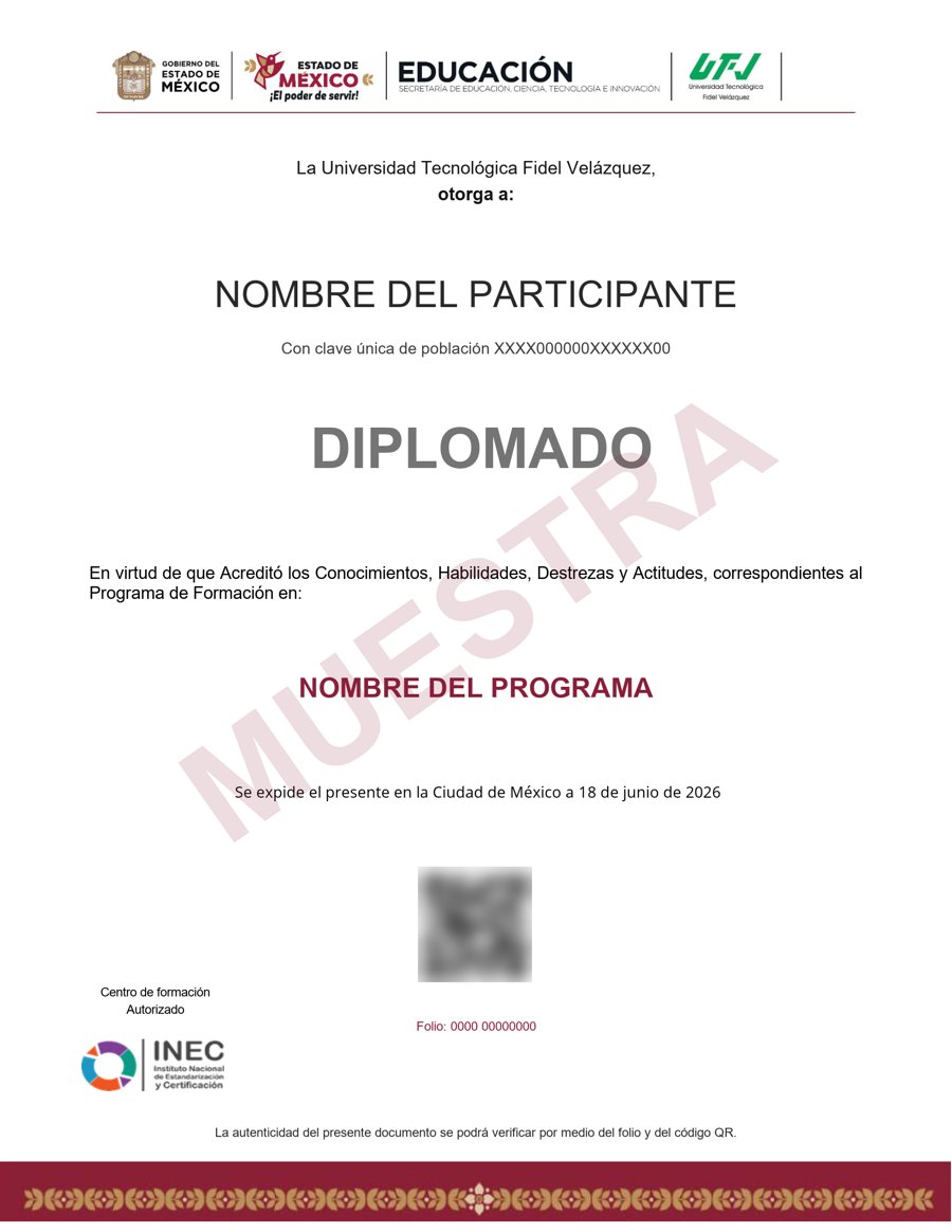
Muestra · verificable por folio y QR
- Emitido por la Secretaría de Educación Pública (SEP), a través del Gobierno del Estado de México. No es una constancia privada: es un documento oficial, y ese respaldo marca la diferencia frente a otras plataformas en línea.
- Contenido impartido por Alasdair Rae.
- Folio y QR verificables para compartirlo con quien te contrate.
Empieza hoy, a tu ritmo
Un solo pago y acceso inmediato al curso completo durante 12 meses.
- 14 unidades · 160 lecciones · 60 h
- 12 meses de acceso
- 12 cuestionarios de evaluación
- Certificado emitido por la SEP (Gob. del Estado de México) con folio verificable
Sobre tu inscripción
¿Cómo es el pago?
Un solo pago de $2,800 MXN. No hay mensualidades ni cargos recurrentes.
¿Cuánto tiempo tengo acceso?
12 meses desde tu inscripción, 24/7, para avanzar a tu ritmo.
¿Quién imparte el contenido?
El curso es impartido por Alasdair Rae; INEC gestiona tu inscripción, evaluación y certificado.
¿Qué pasa cuando vence mi acceso?
Puedes renovar tu cuenta tú mismo desde la plataforma, sin trámites ni esperas.

